Geoinformatics Notes 12th Geography
12th Geography Lesson 6 Notes in English
6] Geoinformatics

Introduction
- Geoinformatics is the integration of remote sensing, Global Navigation Satellite System and Geographic Information System dealing with spatial information.
- The advent of remote sensing, Global Navigation Satellite System and Geographic Information System has made significant changes in surveying and map making.
- A basic understanding of these components is crucial for carrying out various types of surveys, navigation, hydrology, disaster management, etc.
Remote sensing
- Remote sensing is an integrated discipline encompassing some branches of arts, science and technology of collecting information about the terrestrial objects using camera and sensor system.
- The field of Remote Sensing and GIS has become exciting with rapidly expanding opportunities.
- Geoinformatics has three major components namely remote sensing, GIS and GNSS.
Elements of Remote Sensing
1. Energy Source
- The primary requirement for remote sensing is to have an energy service, which provides electromagnetic energy to the target of interest.
- The sun being a major source of energy, radiation and illumination having a sharp power allows capturing reflected light with conventional cameras and films.

2. Radiation and the Atmosphere
- The energy is required to illuminate the target.
- This energy is in the form of Electromagnetic radiation.
- Electromagnetic radiation is a dynamic form of energy that propagates as wave motion at a velocity in space.
3. Interaction with the target
- The interaction of Electromagnetic radiation with the target is important to remote sensing for two main reasons.
- First, information carried Electromagnetic radiation reflected by the earth’s surface is modified while traversing through the atmosphere.
- Second, the interaction of Electromagnetic radiation with the atmosphere can be used to obtain useful information about the atmosphere itself.
- The total energy is subjected to modification by the several physical process, scattering, absorption and refraction.
- Scattering is the re-direction of Electromagnetic radiation by particles suspended in the atmosphere or by large molecules of atmospheric gases.
- The amount of scattering depends upon the size of the particles and their abundance.
- The wave length of radiation, depth of the atmosphere through which the energy is travelling.
- Absorption is the process by which the gas molecules present in the atmosphere strongly absorb the Electromagnetic radiation through the atmosphere in certain spectral bands.

4. Recording of energy by the sensor
- After the energy has been scattered by or emitted from the target, we require a sensor (remote not in contact with the target) to collect and record the electromagnetic radiation.
- A sensor is highly sensitive to all the wave lengths yielding spatially detailed data on absolute brightness.
- On the basis of the source of electromagnetic energy, the sensor can be classified into two ways.
- They are active sensor or passive sensor.
- Active sensor generates and uses its own energy to illuminate the target and records the reflected energy.
- It operates in the microwave regions of the electromagnetic spectrum.
- Their wave lengths are longer than 1 mm.
5. Transmission, Reception and Processing
- The energy recorded by the sensor has to be transmitted in electronic form, to a receiving and processing station where the data processed into an image.
- The Image processing methods may be grouped into three functional categories such as Image Restoration, Image Enhancement and Information Extraction.
Image Restoration:
- Restoration processes are designed to recognize and compensate for errors, noise and geometric distortion introduced into the data during the scanning transmission and recording processes.
- The objective is to make the image resemble the original scene.
- Image restoration is relatively simple because the pixels from each band are processed separately.
Image Enhancement:
- Enhancement is the modification of an image, to alter its impact on viewer.
- General enhancement distorts the original digital values; therefore enhancement is not done until the restoration processes are completed.
Information extraction:
- Image restoration and enhancement process utilize computers to provide corrected and improved images for study by human interpreters.
- The computer makes no decision in these procedures.
- The human operator must instruct the computer and must evaluate the significance of the extracted information.
6. Interpretation and Analysis
- Image interpretation is defined as the act of examining images to identify objects and judge their significance.
- An interpreter studies remotely sensed data and attempts through logical process to detect, identify, measure and evaluate the significance of environment and cultural object pattern and spatial relationship.
- The quality of an image is based on the inherent characteristics of the objects.
- Further it depends on the following aspects.
- Sensor characteristics
- Season of the year, time of the day when the photo is taken
- Atmospheric effects
- Resolution of the image on scale.
- Image motion etc.
- Image interpretation is essential for the efficient and effective use of the data.
- The elements of image interpretation such as image tone, shape, size, pattern, image texture, shadow and association are helpful to identify the exact target and to analyse.
Classification of remote sensing
- On the basis of the sources of electromagnetic energy, the remote sensing can be classified as passive and active remote sensing.
- In a simple way, we can understand that the passive remote sensing is similar to taking a picture with an ordinary camera where as active remote sensing is analogous to taking picture with camera having built-in flash.

- On the basis of the energy source, the active remote sensing generates and uses its own energy to illuminate the target and records the reflected energy where as the passive remote sensing depend on solar radiation to illuminate the target.
- On the basis of region of spectrum in which they operate, the active remote sensing operate in the microwave region of the electromagnetic spectrum where as the passive remote sensing operate in the visible and infrared region of the electromagnetic spectrum.
- The wave lengths of the active remote sensing are longer than 1 mm where as the passive remote sensing, the wave length range from 0.4 to 1.0 mm.
- Some examples of active sensors are fluoro sensor and Synthetic Aperture Radar (SAR).
- Passive sensors record radiation reflected from the earth’s surface.
- The source of this radiation must come from outside the sensor; in most cases, this is solar energy.
- Because of this energy requirement, passive solar sensors can only capture data during daylight hours.
- Active sensors are different from passive sensors. Unlike passive sensors, active sensors require the energy source to come from within the sensor.
- A laser-beam remote sensing system is an active sensor that sends out a beam of light with a known wavelength and frequency.
- This beam of light hits the earth and is reflected back to the sensor, which records the time it took for the beam of light to return.
Remote sensing platform
- The platform is a stage to mount the camera or sensor to acquire the information about a target under investigation.
- Based on the altitude above the earth surface, the platform can be classified as Ground borne platform, Air borne platform and Space borne platform.
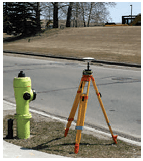
Ground borne platform
- Ground based platforms are used to record detailed information about the surface which is compared with information collected from aircraft or satellite sensors.
- They are close to the ground.
- These sensors may be placed on a ladder, scaffolding tall-building, crane etc.

- A wide variety of ground based platforms are used in remote sensing.
- Some of the more common ones are hand held devices, tripods, towers and cranes.
- Instruments that are ground-based are often used to measure the quantity and quality of light coming from the sun or for close range characterization of objects
- Permanent ground platforms are typically used for monitoring atmospheric phenomenon although they are also used for long-term monitoring of terrestrial features.
Air borne platform
- Aircrafts are generally used to acquire aerial photographs for photo interpretation and photogrammetric purposes.
- They are classified into two types. They are
- Low altitude aerial remote sensing
- High altitude aerial remote sensing
Balloon
- Balloons are used for remote sensing observation (aerial photography) and nature conservation studies.
- The first aerial images were acquired with a camera carried aloft by a balloon in 1859.
- Balloon floats at a constant height of about 30 km.

Drone
- Drone is a miniature remotely piloted aircraft.
- It is designed to fulfil requirements for a low cost platform, with long endurance, moderate payload capacity and capability to operate without a runway or small runway.
- Drone includes equipment of photography, infrared detection, radar observation and TV surveillance.
- It uses satellite communication link.
- An onboard computer controls the payload and stores data from different sensors and instruments.
- The unique advantage is that it could be accurately located above the area for which data was required and capable to provide both night and day data.
Aircraft
- The first known aerial photograph was taken in 1858 by French photographer and balloonist, Gaspar Felix Tournachon, known as “Nadar“.
- In 1855 Special aircraft with cameras and sensors on vibration less platforms are traditionally used to acquire aerial photographs and images of land surface features.
- While low altitude aerial photography results in large scale images providing detailed information on the terrain, the high altitude smaller scale images offer advantage to cover a larger study area with low spatial resolution.
Space borne platform
- The satellites are normally used for the space borne remote sensing. The satellite moves in their orbit.
- The closed path of a satellite around the earth is called its orbit.
- These platforms are freely moving in their orbit around the earth and the entire earth or any part of the earth can be covered at specified intervals.
- The coverage mainly depends on the orbit of the satellite.
- It is through these space borne platforms, we get the enormous amount of remote sensing data.
- In space borne remote sensing, sensors are mounted on-board a spacecraft (space shuttle or satellite) orbiting the earth.
- Space borne remote sensing provides the following advantages:

- Large area coverage.
- Frequent and repetitive coverage of an area of interest.
- Quantitative measurement of ground features using radio metrically calibrated sensors.
- Semi automated computerised processing and analysis.
- Relatively lower cost per unit area of coverage.
Types of satellite orbits
- Satellite orbits are designed according to the capacity and objective of the sensors they carry.
- Depending on their altitude, orientation and rotation relative to the earth satellites can be categorized as
- Geostationary satellite
- Polar Orbiting and Sun-Synchronous satellite
- Spy satellite
Geostationary Satellites
- Geostationary Satellite is an equatorial west to east satellite orbiting the earth at an altitude of 35000 km, the altitude at which it makes on revolution in 24 hours.
- These platforms are covering the same place and give continuous near hemispheric coverage over the same area day and night.

- These satellites are put in equatorial plane orbiting from west to east.
- Its coverage is limited to 70°N to 70°S latitudes and one satellite can view one-third globe.
- These are mainly used for communication and meteorological applications viz. GOES, METEOSAT, INTELSAT, and INSAT satellites.
- On June 19, 1981 India launched its first geostationary satellite called APPLE.
- It was an experimental communication satellite launched by the Indian Space Research Organisation (ISRO) with a C-band transponder.

- The Ariane Passenger Payload Experiment (APPLE) was ISRO’s first indigenous, experimental communication satellite.
Sun-synchronous satellites
- As the satellite orbits the Earth from pole to pole, its east-west position would not change if the Earth did not rotate.

- However, as seen from the Earth, it seems that the satellite is shifting westward because the Earth is rotating (from west to east) beneath it.
- This apparent movement allows the satellite swath to cover a new area with each pass.
- All the remote sensing resource satellites may be grouped in this category.
- Few of these satellites are LANDSAT series, SPOT series, IRS series, NOAA SEASAT, TIROS, HCMM, SKYLAB, and SPACE SHUTTLE etc.
Spy satellites
- Spy satellites are robotic observational platforms that orbit the Earth in order to image its surface and to record radio signals for military and political purposes.
- They transmit their data to Earth, where it is interpreted by specialists in centralised, secretive facilities such as the U.S. National Photographic Interpretation Centre in Washington, D.C.
- Spy satellites have been essential not only to military operations and the formation of national policy but to the verification of arms control treaties such as SALT I, SALT II, etc.
- The four basic types of spy satellite are:
(1) photo reconnaissance systems that take pictures in visible and infrared light,
(2) infrared telescopes designed to detect missile launches,
(3) radars that image sea or land even through cloud cover and in darkness, and
(4) signals intelligence (SIGINT) satellites (also termed “ferrets“), which are optimised either for characterising ground- based radar systems or for eavesdropping on communications.
- Sometimes photo reconnaissance and SIGINT functions are combined in single, massive platforms such as the U.S. Keyhole-series satellites.
- Although a number of nations have launched spy satellites, the U.S. and the Soviet Union are responsible for by far the greatest number.
- The Russian Federation, which inherited most of the Soviet Union’s space system after 1991, has been unable to afford the cost of adequately updating its spy satellite network.
- In contrast, the U.S. has continued to deploy ever-more-sophisticated systems in a steady stream.
- Thus, the majority of spy satellites in orbit today, including all the most capable units, are U.S.-owned.
- Early U.S. Spy Satellites: Corona, MIDAS, SAMOS.

Applications of remote sensing
1. Agriculture
- The satellites have ability to image individual fields, regions and countries on a frequent revisit cycle.
- Customers can receive field-based information including crop identification, crop area determination and crop condition monitoring (health and viability).
- Satellite data are employed in precision agriculture to manage and monitor farming practices at different levels.
2. Forest Management
- The forest – fire, sudden deforestation, encroachment of forest- land are recent challenges to the ecologist.
- It can be easily identified and curbed with the help of remote sensing satellite pictures.
3. Geology various fields
- Remote sensing techniques used in geology are
- Lithological mapping
- Structural mapping

NASA launches world’s lightest satellite designed by 18-year-old Tamil Nadu student.

- India once again broke a global space record by launching the world’s lightest satellite weighing a mere 64 grams, called Kalamsat.
- It was designed and developed not by professional space scientists and engineers, but by 18-year-old Tamil Nadu student Rifath Sharook and his team.
- The tiny satellite, named after Abdul Kalam, was flown by a NASA sounding rocket on 22 June, 2017 and Kalamsat was the only Indian payload in the mission.
- Mission director Srimathy Kesan that the total flight time of the rocket was 240 minutes.
- The satellite, assembled at her T.Nagar residence in Chennai.
- The satellite was separated from the rocket after spending 125 minutes in the space’s micro-gravity environment.
- Sharook’s project, the first to be manufactured via 3D printing, got selected through a competition, ‘Cubes in Space’, sponsored jointly by NASA and ‘I Doodle Learning’.
- The project aims to take the performance of new technology to space.
- Geomorphological mapping
- Mineral exploration
- Hydrocarbon exploration
- Sedimentation mapping and monitoring
- Geo-hazard mapping
4. Oceanography
- Satellite remote sensing plays an important role in coastal zone management.
- There it allows us to locate and regularly monitor various aspects such as bathymetry (the measurement of the depth of water in water bodies), chlorophyll content, suspended sediment concentration, etc.

5. Cartography
- Remote sensing aids in extensive surveys that are made from high altitudes to show the urban development, rural development, mountain areas, desserts, etc which help the cartographers.
- High-resolution satellite cameras located at altitudes of several hundred kilometres can record details as small as a few metres on the surface of the Earth.
6. Meteorology
- The radar system is basically used to collect the weather data.
- It collects meteorological data from unmanned land/ ocean based Data collection platforms and serves as a communication satellite for rapid exchange of meteorological data among centres and for rapid dissemination of weather forecasts warnings etc, to user agencies.

7. Topography
- Topography specifically involves the recording of relief or terrain, the three– dimensional quality of the surface, and the identification of specific landforms.
- Topographic maps usually portray both natural and manmade features.
- They show and name works of nature including mountains, valleys, plains, lakes, rivers, and vegetation.
- They also identify the principal works of man, such as roads, boundaries, transmission lines, and major buildings.
8. Urban Planning
- These information systems also offer interpretation of physical (spatial) data with other socio-economic data, and thereby providing an important linkage in the total planning process and making it more effective and meaningful.
- Digitization of planning base maps has facilitated updating of base maps wherever changes have taken place in terms of land development etc.
- Superimposition of any two digital maps which are on two different scales is feasible.

Geographic Information System (GIS)
- The Geographic information systems have emerged in the past two decades as an essential tool for urban and resource planning and management.
- It includes the functions of data entry, data display, data management, information retrieval and analysis.
- While GIS deals with entire geography of the earth including land, ocean and atmosphere, the art, science and technology dealing with the acquisition, storage, processing, production, presentation and dissemination of the earth’s information is called the Geoinformatics.
- It is the popular means of studies in recent decades which cater the real and useful information to the field of Geography, Environmental Studies, Town planning, Rural development studies, and Defense and Agricultural promotion.
Generation of the computers
- 1940 – 1956: First Generation – Vacuum Tubes
- 1956 – 1963: Second Generation – Transistors
- 1964 – 1971: Third Generation – Integrated Circuits
- 1972 – 2010: Fourth Generation – Microprocessors
- 2010 – Fifth Generation – Artificial Intelligence

Components of GIS
- The components of GIS can be broadly classified into five types. They are mentioned below.
A. Hardware
- Hardware is Computer on which GIS software runs.
- Nowadays there are a different ranges of computer, it might be Desktop or server based.
- ArcGIS Server is server based computer where GIS software runs on network computer or cloud based.
- For computer to perform well all hardware components must have high capacity. Some of the hardware components are:
- Motherboard, Hard driver, processor, graphics card, printer and so on.
- These all component function together to run GIS software smoothly.
B. Software
- Next component is GIS software which provides tools to run and edit spatial information.
- It helps to query, edit, run and display GIS data.
- It uses RDBMS (Relational Database Management System) to store the data.
- Few GIS software list: ArcGis, ArcView 3.2, QGIS, SAGA GIS.
- Software Components: GIS Tools, RDBMS, Query Tools, GUI and Layout.
C. Data
- Geographic data and related tabular data can be collected in-house compiled to custom specifications and requirements (or) purchased from a commercial data provider.
- A GIS can integrate spatial data with other existing data resources often stored in a corporate data base management System.
- The data can be broadly classified as
- i. Attribute data
- ii. Spatial data
- iii. Remote sensing data
- iv. Global data base.
- You will learn in detail about each of the above classification of data in higher studies.

D. People
- The GIS technology is used by a huge number of industrialists and agencies to help plan, design, engineer, build and maintain information infrastructures that affects our everyday lives.
E. Methods or Procedures
- Methods here refer to well-defined, consistent procedures that are required to produce accurate, reproducible result.
- A neatly conceived implementation plan and business rules are the models and operating practices are unique to each organization.
- There is need to properly integrate the sophisticated tool through bringing out well-defined procedures in well documented form into the entire business strategy and operation to make the technology effective.
- Meta data i.e., (data about the data) is the key for documenting these processes.
Functions of GIS
- The functions of GIS describe the steps that have to be taken to implement a GIS.
- These steps have to be followed in order to obtain a systematic and efficient system.
- The steps involved are data capture, data storage (GIS Data Models), manipulation and analysis.
Data Capture
- The input of data into a GIS can be achieved through many different methods of gathering.
- For example, aerial photography, scanning, digitizing, GNSS is just a few of the ways a GIS user could obtain data.
- Digitization: A conversion process which converts paper maps into numerical digits that can be stored in the computer.
- Digitizing simplifies map data into sets of points, lines or cells that can be stored in the GIS computer.
- In this stage, digitization is carried out.
- There are two basic methods of digitization: Manual digitizing & scanning.
Data Storage
- Some data is stored such as a map in a drawer, while others, such as digital data, can be as a hardcopy, stored on CD or on your hard drive.
- Once the data have been digitally compiled, digital map files in the GIS are stored on magnetic or other digital media.
- Data storage is based on a Generic Data Model that is used to convert map data into a digital form.
- The two most common types of data models are Raster and Vector.
- Both types are used to simplify the data shown on a map into a more basic form that can be easily and efficiently stored in the computer.
Data Manipulation
- The digital geographical data can be edited, this allows for many attribute to be added, edited, or deleted to the specification of the project.
- Once data are stored in a GIS, many manipulation options are available to users.
- These functions are often available in the form of “Toolkits.”
- A toolkit is a set of generic functions that a GIS user can employ to manipulate and analyse geographical data.
- Toolkits provide processing functions such as data retrieval measuring area and perimeter, overlaying maps, performing map algebra, and reclassifying map data.
- Data manipulation tools include coordinate change, projections, and edge matching, which allow a GIS to reconcile irregularities between map layers or adjacent map sheets called Tiles.
Query and Analysis
- GIS was used widely in decision making process for the new commission districts.
- We use population data to help establish an equal representation of population to area for each district.
- The heart of GIS is the analytical capabilities of the system.
Global Navigation Satellite System (GNSS)
- GNSS refers to the collection of the world’s global satellite based positioning systems.
- It includes GPS (United States) GLONASS (Russia) GALILEO (European Union) BEODOU (China) IRNSS (India) QZSS (Japan).
- GNSS can provide centimetre level accuracy with a low-cost receiver, if an error correction technique is used.
- GNSS are recognized to be the systems of choice in outdoor environments and, to a great extent, one of the most accurate source of position (and precise timing) information when it is available.
- The first satellite navigation system was Transit, a system deployed by the US military in 1960’s.
- Transit’s operations were based on the Doppler Effect: the satellites travelled on well-known paths and broadcast their signals on well-known radio frequency.
- The received frequency will differ slightly from the broadcast frequency because of the movement of the satellite with respect to the receiver.

- The satellite broad cast signals that contains orbital data (from which the position of the satellite can be calculated) and the precise time, the signals is transmitted.
- There are multiple constellations of GNSS satellites orbiting the earth.
- GNSS satellites’ orbit situated about 20,000 km above the earth’s surface.
- They are moving very fast, several kilometres per second.
- The latest generation of GNSS satellites (Block IIF) weight over 1,400 kg.
GNSS system operated in different countries
The following are the Global Navigation satellite Systems:
GPS (United States)
- GPS was the first GNSS system.
- GPS was launched in the late 1970s by the United States Department of Defence.
- It uses a constellation of 24 satellites, and provides global coverage.
GLONASS (Russia)
- The premier Soviet military navigation network was to be comprised of Uragan satellites.
- At the end of the Cold War, the constellation was unclassified under the name GLONASS — a Russian abbreviation of Global Navigation Satellite System.
- Global Navigation Satellite System by Russian Aerospace Defence Forces is a space-based satellite navigation system.
- The life style of GNSS satellites 5-7 years and new satellites are to be launched after a specific time interval in order to fill the gap due to ageing satellites.
- GLONASS proves very beneficial for Russian territory by 2010.
- In 2011, restoration of system is improved to enable full global coverage.
GALILEO (European Union)
- Galileo is Europe’s own global navigation satellite system, providing a highly accurate, guaranteed global positioning service under civilian control.
- Currently providing Initial Services, Galileo is interoperable with GPS and Glonass, the US and Russian global satellite navigation systems.
- By offering dual frequency as standard, Galileo is set to deliver real-time positioning accuracy down to the metre range.
- The Galileo constellation in space will comprise 30 satellites in total.
- There will be 24 operational satellites, plus 6 spare satellites, circulating in medium Earth orbit on three orbital planes.
BEIDOU (China)
- BeiDou Navigation Satellite System (BDS) is a Chinese satellite Navigation system. It consists of two separate satellite constellations.
- The first BeiDou system is officially called the BeiDou Satellite Navigation Experimental System and also known as BeiDou-1.
- On December 27, 2018, Beidou-3 officially began to provide global services.
- The Beidou-3M/G/I satellites represent the orbital segment of the third phase of the Chinese Beidou navigation system which uses satellites in Medium Earth Orbit and Geosynchronous Orbit and is also known as the Compass Navigation Satellite System.
Japan Aerospace Exploration Agency (QZSS Japan)
- QZSS is a regional navigation satellite system that provides service to Japan and the Asia-Oceania region.
- QZSS (nickname of Michibiki – meaning to ‘guide’ or ‘show the way’)
- QZSS is a Japanese satellite positioning system composed mainly of satellites in quasi-zenith orbits (QZO).
- However, the term “Quasi-Zenith Satellite (QZS)” can refer to both satellites in QZO and geostationary orbits (GEO).
- For that reason, the name “QZO satellite” is used when it is necessary to specifically refer to satellites in QZO.
- Satellite positioning systems use satellite signals to calculate position information.
- The QZSS is sometimes called the “Japanese GPS.”
IRNSS (Indian Regional Navigational Satellite System)

- IRNSS is an autonomous regional satellite navigation system being developed by ISRO (Indian Space Research Organization).
- It is designed to provide geospatial positioning information within the Indian sub- continent.
- It enables users to map out their location (altitude, longitude and latitude).
- The objective of developing IRNSS was to cut down India’s dependency on foreign navigation satellite systems.
- It provides location information service to users in India and the region extending for up to 1,500 km from the Indian boundary.
- This is the primary service area of IRNSS information service to users in India and the region extending up to 1500 km from Indian boundary.
- IRNSS aims to provide the following services:
- Standard Positioning Service (SPS) for civilian, research & commercial use,
- Restricted Service (RS) for authorized users.
- For example in defence, IRNSS is used for ground, aerial and marine navigation, disaster management, mobile phone integration, mapping and visual & voice navigation for drivers, among others.
Applications of GNSS
- GNSS applications are widely used to get the quick information about a particular field.
- Some of the commercial applications are Consumers, Transportation, GIS, Machine Control Port Automation, Precision Agriculture, Construction, Marine Mining, Unmanned Vehicles Surveying, Defence, and Aerial Photogrammetry, etc.
Consumer
- GNSS technology has been adopted by the consumer market, in an ever-increasing range of products.
- GNSS receivers are now routinely integrated into smart phones, to support applications that display maps showing the location of and best route to stores and restaurants.
Transportation
- In rail transportation, GNSS is used to track the location of locomotives and rail cars, maintenance vehicles and wayside equipment, for display at central monitoring consoles.
- Knowing the precise location of rail equipment reduces accidents, delays, and operating costs, enhancing safety, track capacity, and customer service.
- In aviation, GNSS is being used for aircraft navigation from departure, en route, to landing.
Port Automation
- Using GNSS, shipping hubs can improve their operating efficiency by tracking the movement and placement of containers about their yards.
- Many cranes are equipped with GNSS based steering devices that determine the crane’s position and keep it travelling in the desired path, improving accuracy and productivity as well as the safety of operators and workers on the ground.

Machine Control
- GNSS technology is being integrated into equipment such as bulldozers, excavators, graders, pavers and farm machinery to enhance productivity in the real-time operation of this equipment, and to provide situational awareness information to the equipment operator.

Precision Agriculture
- In precision agriculture, GNSS-based applications are used to support farm planning, field mapping, soil sampling, tractor guidance, and crop assessment.
- More precise application of fertilizers, pesticides and herbicides reduces cost and environmental impact.
Surface Mining
- GNSS information is being used to efficiently manage the mining of an ore body and the movement of waste material.
- GNSS equipment installed on shovels and haul trucks provides position information to a computer-controlled dispatch system to optimally route haul trucks to and from each shovel.
Survey
- Using GNSS, it is possible for a single surveyor to accomplish in one day what might have taken a survey crew of three people a week to complete.
- Determining a new survey position once required measuring distances and bearings from an existing (known) survey point to the new point.
MORE TO KNOW:
India reached Mars in 1st attempt
- India is the only one country which has reached to the mars in its first attempt.
The Gaofen 4
- The Gaofen 4 is the world’s most powerful GEO spy satellite (launched in 2015) which can provide instant coverage of earthquake or typhoon hit areas to support humanitarian relief.
- It will also allow China to monitor strategic foreign sites such as WMD facilities and naval bases inside its observation box.
The battle for the world’s fastest supercomputer has a new victor: Summit
- According to IBM, Summit is able to achieve 200 peta flops of performance, or 200 quadrillion calculations per second.

- This power marks a significant gain on Sunway TaihuLight, which performs a still- staggering 87 petaflops.
- Summit holds more than 10 peta bytes of RAM, and its funding came as part of a $325 million program funded by the United States Department of Energy.
- Each of Summit’s 4,608 nodes holds two IBM Power9 chips that run at 3.1 GHz.