Weather And Climate Notes 8th Social Science
Weather And Climate Notes 8th Social Science
8th Social Science Lesson 6 Notes in English
6. Weather And Climate
Introduction
- Climate is one of the basic elements in the natural environment. It affects landforms, soil types, fauna and flora. It influences man to a large extent.
- Weather and climate influence man’s activities like what we eat, wear, the house in which we live and work, farming, sailing, fishing, modern transport and even our play time etc.
- Hence one should have knowledge about the weather and climate.
- So, in this chapter we are going to learn about weather and climate, its elements and how they influence our lifestyle.
Weather
- Weather is the day today conditions(state) of the atmosphere at any place as regards sunshine, temperature, cloud cover, Wind fog condition, air pressure, humidity, precipitation and such other elements.
- It refers to short periods like a day, a week, a month or a little longer and as such the weather changes from time to time in a day and one period to the other in an year.
- In the morning the weather might be sunny with a clear sky in a place and evening there might be clouds and rain.
- Similarly the weather is cool in winter and hot in summer. We often hear people saying “Today the climate is good or bad”.
- It is incorrect to say like that. Instead it has to be said that the weather is good or bad.
- We could observe the television news readers saying weather report and not the climate report for e.g. cricket match have been postponed due to bad weather etc.
8th Social Book Back Questions
Climate
- Climate is generally defined as the average conditions (state) of the weather of a place or a region.
- The average atmospheric conditions are determined by measuring the weather elements for a long period of time which is usually for 35 years.
- The elements of weather and climate are the same. The climate does not change often like weather.
Controlling factors of weather and climate
- Angle of the sun’s rays, the length of daytime, altitude, distribution of land and water bodies, location and direction of mountain ranges, air pressure, winds and ocean currents are the major factors which affect the weather and climate of a region.
- The earth is spherical in shape. So, the sun’s rays fall unevenly on the earth’s surface.
- The Polar regions receive slanting sun’s rays. Hence there is little or no sunlight, thus there is an extreme cold winters.
- Vertical sun’s ray’s fall directly on regions around the equator, hence the climate is very hot and almost no winters.
- The difference in temperature makes the air and water move in currents. Warm air rises and creates more space for air beneath, while cool air settles down.
Elements of weather and climate
Temperature, rainfall, pressure, humidity and wind are the major elements of weather and climate.
Temperature
- Temperature is one of the key elements of weather and climate. The earth and its atmosphere get heated from the sun through insolation.
- The degree of heat present in the air is termed as temperature. Apart from sun’s rays, the heat in air also depends the atmospheric mass to a small extent.
- Temperature varies with time due to changes in the level of radiation which reach the earth surface.
- This is due to motions of the earth (The rotation and revolution) and inclination of the earth’s axis.
- The temperature influences the level of humidity, the process of evaporation, condensation and precipitation.
- Heat energy from solar radiation is received by the earth through three mechanisms. They are radiation, conduction and convection.
- The Earth’s atmosphere is heated more by terriestrial radiation than insolation.
Factors affecting the distribution of temperature
Latitude, altitude, nature of land, ocean currents, prevaling winds, slope, shelter and distance from the sea, natural vegetation and soil are the major factors which affect the distribution of temperature.
Measuring Temperature
- The temperature of a unit volume of air at a given time is measured in scales like Celsius, Fahrenheit, and Kelvin.
- Meteorologist measures the temperature by the Thermometer, Stevenson screen and minimum and maximum Thermometer.
- The energy received by the earth through insolation is lost by outgoing radiation. Atmosphere is mainly heated by outgoing radiation from 2 to 4pm.
- So the maximum temperature is recorded between 2 and 4 pm regularly and minimum temperature is recorded around 4 am before sunrise.
Mean Temperature
- The average of maximum and minimum temperatures within 24 hours is called mean daily temperature [(87oF+73oF)/2=80oF].
- Diurnal range of temperature is the difference between the maximum and minimum temperatures of a day.
- Annual range of temperature is the difference between the highest and lowest mean monthly temperatures of a year.
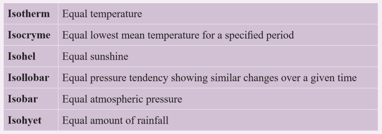
- The distribution of temperature is shown by means of Isotherms. Isotherms are imaginary lines which connect the same temperatures of different places.
Heat zones of the earth
- The fact that the earth is spherical in shape results in different parts of the earth getting heated differently.
- Based on the heat received from the sun, Earth is divided into three heat zones. They are
Torrid Zone
- It is a region between the tropic of cancer and the tropic of Capricorn.
- This region receives the direct rays of the sun and gets the maximum heat from the sun.
- This zone known as the torrid or the tropical zone
Temperate zone
- This zone lies between the Tropic of cancer and the Arctic circle in the Northern Hemisphere and between the Tropic of Capricorn and the Antartic circle in the southern Hemisphere.
- This zone gets the slanting rays of the sun and the angle of the sun’s rays goes on decreasing towards the poles.
- Thus this zone experiences moderate temperature.
Frigid Zone
- The frigid zone lies between the Arctic circle and the North Pole and between the Antartic circle and the South Pole.
- This region also known as Polar region.
- Since it receives the extremely low temperature throughout the year, these regions are covered with snow.

Rainfall
- Rain is a liquid water in the form of droplets that have condensed from atmospheric water vapour and then become heavy enough to fall under gravity.
- Rain is a major component of the water cycle and is responsible for depositing most of the fresh water on the Earth. It is the source of water for all purposes.
- There is a close relationship between the temperature and rainfall distribution.
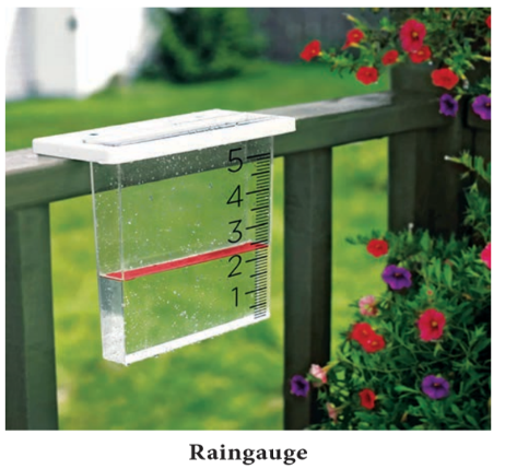
- Generally rainfall is high in the equatorial region and decreases gradually towards poles. Rainfall is measured by Raingauge.
Air Pressure
- The weight of air above a given area on the earth’s surface is called atmospheric pressure or air pressure.
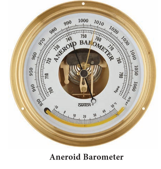
- The air pressure is measured by Barometer. The standard air pressure at sea level is 1013.25mb.
- At the earth’s surface the pressure is 1.03kg.per sq cm. The variation in standard atmospheric pressure is found both horizontally and vertically.
- Based on the level of pressure, it is categorised into low pressure and high pressure.
- Low pressure area is an area in the atmosphere where the pressure is lower than its surrounding areas.
- In this situation, the wind from the surroundings blow towards the centre of low pressure.
- High pressure is an area of atmosphere where the barometric pressure is higher than its surrounding areas.
- In this case, the wind from the centre of high pressure blows towards the surrounding low pressure areas.
- Low pressure system is marked as “L” on weather map, where as the high pressure system is marked as “H”.
- Low pressure systems are also called as a depression and cyclones. High pressure system is called anti cyclones. Low pressure leads to cloudiness, wind, and precipitation.
- High pressure leads to fair and calm weather. Isobar is used to show the distribution of air pressure.
- Humans are not sensitive to small variation in air pressure.
- But the small variations in pressure that do exist largely determine the wind and storm patterns of the earth.
- The distribution of atmospheric pressure is controlled by altitude, atmospheric temperature, air circulation, earth rotation, water Vapour, atmospheric storms etc.
Measuring air pressure
Meteorologist uses barometer/aneroid barometer to measure the air pressure. Barograms are used for recording continuous variation in atmospheric pressure.
Humidity
- Humidity refers to the degree of water vapour present in the atmosphere in gaseous form in particular time and place.
- It ranges from 0-5 percent by volume in atmosphere. Climatically it is an important constituent of the atmosphere and its quantity depends on the level of temperature.
- So, the level of humidity decreases towards poles from equator. Humidity is expressed in different ways.
- Specific humidity is a ratio of the water vapor content of the mixture to the total air content on a mass basis. It is expressed in grams of vapour per kilogram of air
- Absolute Humidity is the mass or weight of water vapour present per unit volume of air. It is expressed usually in grams per cubic meter of air.
- Relative humidity is a ratio between the actual amount of water vapour present in the air and the maximum amount of water vapour it can hold at a given temperature. It is expressed as a percentage.
- Generally, warm air holds more water vapour than the cold air. When relative humidity reaches 100%, the air gets saturated.
- In this condition the temperature is said to be at dew-point. Further cooling will condense the water vapour into the clouds and rain.
- Relative humidity affects human health and comfortness. Very high and very low humidity are injurious to health. It also affects the stability of different objects, buildings and electrical applications.
Measurement of Humidity
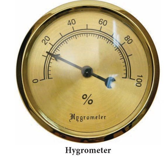
- Hygrometer is used to measure the humidity. (which comprises wet and dry bulb plate side by side in the Stevenson screen)
Wind
- The horizontal movement of air is called wind. Vertical movement of air is said as air current. The winds move from high pressure to low pressure.
- Unlike other elements a wind is made up of a series of gusts and eddies which can only be felt and not seen.
- Winds get their name from the direction from which they blow i.e, wind blows from south west is called southwest wind.
- The wind systems are broadly categorized into three as follows.
- Planetary winds
- Seasonal winds
- Local winds
- Planetary Winds are the ones which blow almost in the same direction throughout the year. So, they are called as Permanent or planetary winds.
- Trade winds, Westerlies and polar easterlies are the types of prevailing winds. Seasonal winds are those which change their direction according to season in a year. They are called as monsoon winds.
- These winds blow from sea to land during summer and land to sea during winter.
- Local winds are the winds blow over a small area only during a particular time of a day or a short period of a year.
- Land and sea breezes are example of these winds. The Beaufort scale is a scale for measuring wind speed.
- It is based on observation rather than accurate measurement. It is the most widely used system to measure wind speed today.
- The scale was developed in 1805 by Francis Beaufort, an officer of the Royal Navy and first officially used by HMS Beagle.
Measuring wind direction and speed
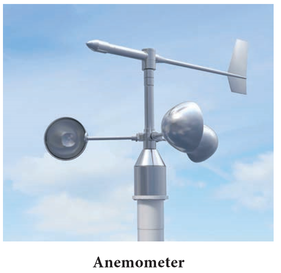
- Meteorologist measures wind direction using wind vane or weather cock. Wind speed is measured by anemometer.
- Wind rose is a diagram used to depict the direction and periods (No. of days) of prevailing winds on map.
- Meteorograph or triple register is an instrument which records wind speed and direction, sunshine and precipitation.
- It also provides graphic representation.
More to Know:
1. Al-Balakhi, an Arab Geographer collected climatic data from the Arab travellers and prepared the First climatic Atlas of the world
2. Brazil has a large area where the average wind speed is low. Gabon, Congo and DR Congo in Africa, Sumatra, Indonesia and Malaysia are the least windy places on earth.
3. With decreasing air pressure, the availability of oxygen to breath also decreases.
- At very high altitudes, atmospheric pressure and available oxygen get so low that people can become sick and even die.
- Mountain climbers use bottled oxygen when they ascend very high peaks.
- They also take time to get used to the altitude as the quick move from high pressure to low pressure can cause decompression sickness.
- Aircraft create artificial pressure in the cabin which makes the passengers remain comfortable while flying.
4. Why Do Your Ears Pop in Airplanes?
As you go up in an airplane, the atmospheric pressure becomes lower than the pressure of the air inside your ears. Your ears pop because they are trying to equalize or match the pressure. The same thing happens when the plane is on the way down and your ears have to adjust to a higher atmospheric pressure.
5. Highest pressure ever recorded
The highest ever air pressure at sea level was recorded at Agata, Russia on 31st December, 1968. The pressure was1083.8mb
6. Lowest pressure ever recorded
The lowest pressure of 870mb was recorded at Typhoon Tip, near Guam, Mariana Island in Pacific Ocean on 12th October, 1979.
7. Highest Temperature ever recorded
The highest temperature ever recorded on the earth is 56.7°C (134°F). It was recorded on 10th July 1913 at Greenland Ranch of Death Valley, California, USA.
8. Lowest Temperature ever recorded
The lowest temperature ever recorded on the earth is −89.2 °C (−128.6 °F; 184.0 K). It was recorded on 21st July, 1983 at Soviet Vostok Station in Antarctica.
9. Temperature varies both horizontally and vertically. Temperature decreases with increasing height is known as Lapse rate which is 6.5 degree celsius per 1000 meters in troposphere.
10. The word Climate is derived from the ancient Greek word “Klimo” which means “Inclination”.
11. Scientific study of weather is called Meteorology and the scientific study of climate is called climatology.
12. Earth’s atmosphere is a layer of gases surrounding the planet earth and retained by the earth’s gravity. It contains about 78% nitrogen, 21% oxygen, 0.97% argon, 0.03% carbon dioxide and 0.04% trace amounts of other gases and water vapour.