Physiography of Tamil Nadu Notes
Physiography of Tamil Nadu Notes
Tamilnadu Notes in English Part 2
2. Physiography of Tamil Nadu
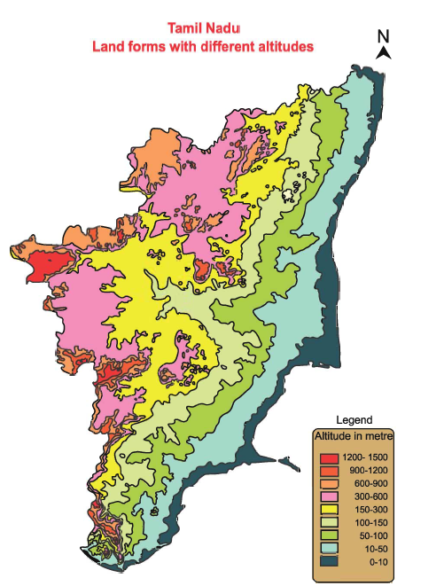
Tamil Nadu has a unique physiography. The hills of the Eastern and Western Ghats surround Tamil Nadu to the Northwest and West, the Bay of Bengal is found to the East and the Indian Ocean to the South. In general, the physiography of Tamil Nadu is a high land which has uneroded, western ghats on the west and low lying coastal and river plains on the east.
Physiography of Tamil Nadu
Geographically Tamil Nadu may be divided into four physical divisions
1) The Hilly region (Western Ghats and Eastern Ghats)
2) The Plateau
3) The Plain and
4) The Coastline.
The Hilly regions of Tamil Nadu
The Western Ghats enters the state through the Nilgiris District and runs up to Kanyakumari district. The Western hilly region is much more complex than the Eastern Ghats. Its average height is from 1000 m to 1500m. the Western Ghats has mountain peaks namely Doddabetta (2637m) and Mukuruthi(2540 m). In the north west of Western Ghats lies the Nilgiri highland region at an height of above 2500 m. In this region, there are few peaks found at a height ranging from 1800 m to 2400 m. The highest peak of Tamil Nadu is Doddabetta. Ooty, Queen of hill station is situated in Nilgiris. The Western Ghats and Eastern Ghats meet at the Nilgiri hills.
From the Nilgiris of Tamil Nadu and Anaimalai hills of Kerala, an offshoot runs at a height of 1500m to 2000 m in the east. These are called Palani hills. To the south of the Palani hills there are two other ranges namely, Varshanadu and Andipatti hills running parallel to the Cardamom hills. Though the Western Ghats is a ontinuous range, it has a gap of 25km at Palghat. To the south of Palghat gap, hills such as Andipatti, Elamalai and Agathiya malai are found. Kambam valley is between Thekkadi hills, Varshanadu hills and Kodaikanal hills. This Valley is considered as the green valley of Tamil Nadu. The gap in between Varshanadu hills and Agathiya malai is called the Shenkottai pass.
The Tamil Nadu hills separating, the plains and the plateaus have two well marked passes, namely, the Attur pass in the south and the Chengam pass in the north. This pass links the Cuddalore and Villupuram district in the plain with the Salem district on the plateau. The Plakkad gap and Shenkottai gap are the only breaks in the long chain of hills that border Tamil Nadu on the west. The Eastern Ghats are not continuous when compared to the Western Ghats. They are dissected into isolated hill ranges extending from northeast to southwest through the districts of Vellore, Dharmapuri and Erode. The average elevation ranges from 1100m to 1600m.
Tamilnadu Administration Notes
Tamil Nadu Land forms with different altitudes
Tamil Nadu Physiography

These hillocks are called by different names in different areas, such as;
- Javadi Hills and Elagiri Hills in Vellore District;
- Shervarayan in Salem District;
- Kalvarayan in Villupuram District;
- Pachaimalai in Thiruchirappalli District;
- Kolli hills in Namakkal District;Chitteri hills are in both Dharmapuri and Salem Districts;
- Gingee hills in Villupuram District;
| The highest hills of Eastern Ghats – Shervarayan (1500- 1600m).
The highest hills of Western Ghats- Anaimalai (2700m) |
Plateaus of Tamil Nadu
The Eastern and Western Ghats meet at Nilgiris plateau. Four km from this plateau, it slopes gently downwards to about 1,800 m towards Coimbatore. It extends from the Nilgiris to Dharmapuri plateau or Baramahal plateau and lies to the west of Shervaroy uplands. This plateau is found with extreme abruptness on all sides. The Baramahal plateau in Dharmapuri district is at an elevation of 300 to 700m which merges with the Mysore plateau in the west. The elevation of the plateau increases from east (120m) to west (300 to 450m). Plateaus of Tamil Nadu can be grouped into two as Coimbatore plateau and Madurai plateau. In between the plateaus isolated hills are also seen. One such isolated hill is Chennimalai of Erode district.
Plains of Tamil Nadu
Plains of Tamil Nadu can be classified into two as coastal plains and rivers plains. The coastal plains of Tamil Nadu extend to a length of 1000 km from Pulicat lake in the North to Kanyakumari in the South and have an average height of 50 metres. The notable beaches found here are the Marina and Rameshwaram beach.
Marina Beach
Marina beach is the second longest beach in the world. It extends upto a distance of 13 km and it is one of the major tourist attractions of Chennai.
Rameswaram Beach
The beach of Ramswaram is famous for its beautiful coastal features. The sea waves rise to a maximum height of only 3 cm and the view looks like a very big river.
The coastal plains of Thiruvallur, Kancheepuram, Cuddalore and Villupuram are together known as the Cholamandalam plains.
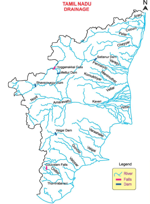
The river plains in Tamil Nadu are formed by the rivers Palar, Cheyyar, Pennar and Vellar in the north; Kaveri and its tributaries in the central region, Vaigai, Vaippar and Thamirabarani in the south.
Rivers of Tamil Nadu
The Northern rivers of Tamil Nadu are Araniyar, Kotralaiyar, Palar, Cheyyar, Kedilam, Manimuthar and Thenpennar. Cheyyar and Agaram are two tributaries of Palar. The main river of the state is Kaveri which originates in Kodagu district of Karnataka. Kaveri and its tributaries in its lower course drain the districts of Nagapattinam, Thanjavur, Thiruvarur and Thirucharapalli. The Kaveri, the Kollidam and the Vellar jointly drain central part of the Tamil Nadu. Srirangam is located between Kaveri and its tributary Kollidam.
In the Kaveri delta, the distributaries such as Kollidam, Manniyar, Vennar, Vettar, Arasalar, Nattar, Mudikondan. Kudamuruti and Veera Cholanar have formed a alluvial plain in a quadrangke shape. Kaveri along with its tributaries, Bhavani, Noyyal, Moyar and Amaravathi is the most important source of canal irrigation. Towards the south of Tamil Nadu, there are few rivers like Vaigai(Madurai), Vaippar (Virudhunagar), Thamirabarani(Thirunelveli), Gundar (Thoothukudi, Ramanathapuram), Chittar (Thirunelveli) and Kothaiyar (Kanyakumari). Most of the soils of the plains of Tamil Nadu are alluvial, formed by these rivers flowing eat. In the southwest of Tamil Nadu is the Suruliyar river that drains a part of Madurai district.
Dear team,
Hightest peak of western ghats is aanaimudi which is in kerala but not aanaimalai
Very helpful